Spring Break Road Trips: National Parks and Scenic Routes
Hit the road this Spring Break and explore the awe-inspiring landscapes of the American Southwest with these itineraries from Las Vegas and Phoenix.

Before You Go
Springtime weather in the desert can vary widely—one day it’s sunny, the next it might be snowing. You’ll find warm temperatures in the valleys of southern California and central Arizona, and plan for cooler temps in the higher elevations of the Grand Canyon, northern Arizona, Utah, Colorado, and Sierra Nevada.
Spring Break Road Trips from Las Vegas
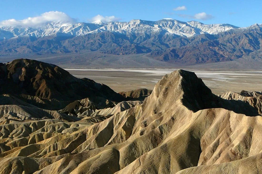
NPS
Death Valley, Huge Trees, & the High Sierra
Las Vegas > Death Valley > Alabama Hills > Sequoia National Park > Kings Canyon National Park > Red Rock Canyon > Las Vegas
Total distance: 1,120 miles
-
Head west from Las Vegas to Death Valley National Park, the hottest, driest, and lowest national park in the U.S. Start at Zabriskie Point, an easy stop with sweeping views. Continue to Badwater Basin, the lowest point in North America at 282 feet below sea level, where you can walk out onto the vast salt flats. Take the 9-mile Artist’s Drive, a scenic loop with colorful mineral-streaked hills.
Where to Camp:Furnace Creek Campground is centrally located, has RV-friendly sites, and is near the park’s main sites.
-
Leave Death Valley in the morning and drive to the Alabama Hills, a stretch of rounded boulders and dramatic rock formations on BLM land at the base of California’s Sierra Nevada mountains. Hike the Mobius Arch Loop Trail, a short and easy walk leading to the famous arch framing Mount Whitney. Explore Movie Road, a scenic drive on graded dirt roads and pavement through backdrops featured in countless Western films.
Spend the afternoon relaxing and taking in the views of the Sierras before settling in for the night.
Where to Camp: The BLM-run Tuttle Creek Campground has first-come, first-served tent and RV sites with awesome views of Mount Whitney, the highest mountain in the contiguous United States.
-
Head into Sequoia National Park, home to the largest trees on Earth. Stop at the General Sherman Tree, the world’s largest by volume, and stroll through the Giant Forest, where towering sequoias rise above the forest floor. Walk across Beetle Rock, an easily accessible granite outcrop with views of the western side of the park.
Seasonal Travel Note: Some high-elevation roads and trails in Sequoia may be closed in early spring due to snow. Check the Sequoia & Kings Canyon National Park Service conditions page before visiting.
Where to Camp: Lodgepole Campground has RV-friendly sites and typically opens in spring, depending on snow levels.
-
Drive into Kings Canyon National Park, one of the least-visited but most dramatic national parks in California. Visit the Grant Grove area, home to the General Grant Tree, one of the world’s largest and designated as the Nation’s Christmas Tree. Take a short walk to Panoramic Point, which offers a spectacular overlook of the surrounding peaks.
Where to Camp: Azalea Campground is located near Grant Grove and open year-round, making it a reliable option for spring travelers.
-
Head south toward Red Rock Canyon State Park, a unique desert landscape known for its red rock cliffs and formations. Stretch your legs on the Hagen Canyon Trail, an easy loop where many movies were filmed. Drive through Red Cliffs Natural Preserve for a picnic stops in a quiet and beautiful setting.
This is a great final night to relax under the stars before you return to Las Vegas.
Where to Camp:Ricardo Campground has RV-friendly sites and water hookups with a classic red rock backdrop.
-
Start the final stretch back to Las Vegas, traveling through the wide-open Mojave Desert. If you have time before returning the RV, stop at Seven Magic Mountains, an outdoor art installation with colorful stacked boulders just outside of the city.

Yosemite National Park & Big Sur
Las Vegas > Mammoth Lakes > Yosemite National Park > Big Sur > Buena Vista Aquatic Recreational Area > Las Vegas
Total distance: 1,165 miles
-
Head toward Mammoth Lakes, a mountain town in the eastern Sierra Nevada. After a long drive, take a short walk around Twin Lakes or soak in Wild Willy’s Hot Springs to unwind.
Where to Camp: Mammoth Mountain RV Park has full hookups and easy access to lakes and trails.
-
Spend a full day taking in Mammoth’s lakes and mountain trails. Hikers will love the easy Convict Lake Loop with beautiful lake views. Ride the gondola to Mammoth Mountain’s summit for panoramic views, plus lunch and exhibits at Eleven53 Café. Take a sunset drive through the June Lake Loop.
Where to Camp: Enjoy a second night at Mammoth Mountain RV Park.
-
Because Tioga Pass (Highway 120 East) is typically closed November–late May/early June due to snow, drive south to Highway 41 North through Fresno to reach Yosemite Valley. Settle into your campsite and take a leisurely walk to Sentinel Bridge to see Half Dome reflected in the Merced River before relaxing for the evening.
Where to Camp: North Pines Campground is located in the heart of Yosemite Valley.
-
Dedicate the day to exploring Yosemite Valley. Visit iconic spots like Tunnel View and El Capitan Meadow. Stop by the Yosemite Valley Visitor Center to learn about the park’s geology, history, and wildlife.
Where to Camp: Stay a second night at North Pines Campground.
-
Leave the mountains behind and drive toward the California coast. Stop in Monterey for a quick visit to Cannery Row or take a whale-watching tour before following Highway 1 into Big Sur. Stop at Bixby Bridge for photos, then take a short walk to see McWay Falls cascading onto a secluded beach.
Where to Camp: Pfeiffer Big Sur State Park Campground, a large campground with RV and tent sites nestled among the redwoods.
-
Walk through the redwood forests at Pfeiffer Big Sur State Park and visit Pfeiffer Beach, where its purple sand and rocky sea stacks create a dramatic scene. Back on the road, stop at Ragged Point for breathtaking ocean views before heading toward Bakersfield.
Arrive at Buena Vista Aquatic Recreational Area in the evening and enjoy a quiet night by the water, breaking up the long drive back to Las Vegas.
Where to Camp: Buena Vista Campground has lakeside sites with electric hookups and a peaceful atmosphere west of Bakersfield.
-
Start the final stretch back to Las Vegas. If time allows, stop at California’s Red Rock Canyon State Park for a short hike or scenic views before completing your journey.

Utah Canyonlands & Colorado
Las Vegas > Moab (Arches & Canyonlands) > Black Canyon of the Gunnison > Ouray & the Million Dollar Highway > Great Sand Dunes > Las Vegas via Flagstaff
Total distance: 1,525 miles
-
Head toward Moab, Utah, the gateway to Arches and Canyonlands National Parks. Upon arrival, take a sunset drive through Arches National Park (no timed entry permit needed after 4pm), stopping at The Windows Section or Double Arch for easy walks.
Note: After April 1, you’ll need a timed entry reservation to enter Arches National Park from 7am–4pm. Reserve your ticket online.
Where to Camp: Devils Garden Campground is inside Arches National Park and has convenient access to nearby trails.
-
Spend the day in Arches National Park. Hike to Delicate Arch early to avoid crowds. Check out the Devils Garden area for longer hikes with multiple arches, or opt a short but challenging loop trails to Sand Dune Arch and Broken Arch. In the evening, get a beer and a burger at the Moab Brewery before returning to camp.
Where to Camp: Second night at Devils Garden Campground.
-
Begin the morning at Canyonlands National Park – Island in the Sky District, hiking ½ mile to Mesa Arch for sunrise. Back on the road, stop at Grand View Point before continuing toward Colorado, arriving in Montrose by late afternoon.
Where to Camp: South Rim Campground is in the Black Canyon of the Gunnison National Park.
-
Explore the Black Canyon of the Gunnison, known for its steep, dramatic cliffs. Drive along the South Rim Road, stopping at overlooks like Pulpit Rock and Painted Wall. Hike the Warner Point Nature Trail for panoramic views or the Rim Rock Trail for close-up canyon vistas.
Note: The South Rim Road is typically open to the South Rim Visitor Center in spring, but sections beyond may close due to snow. Check current conditions before visiting.
Where to Camp: Stay a second night at South Rim Campground.
-
Drive to Ouray, a charming town nestled in the San Juan Mountains. Enjoy a soak in the Ouray Hot Springs, stroll through the historic downtown, or hike a portion of the Ouray Perimeter Trail. Drive the Million Dollar Highway toward Silverton, stopping at Bear Creek Falls and Red Mountain Pass for breathtaking views.
Where to Camp: 4J+1+1 RV Park is centrally located in Ouray with full hookups.
-
Continue south to Great Sand Dunes National Park, home to North America's tallest dunes. Spend the afternoon sandboarding (buy or rent at the visitor center) or hiking up the dunes for expansive views.
Where to Camp: Piñon Flats Campground is inside the park and has views of the dunes and easy trail access.
-
Begin the drive west, stopping in historic Downtown Flagstaff for a break before completing the final stretch to Las Vegas.
Spring Break Road Trips From Phoenix, AZ

Ken Lund // Creative Commons 2.0
Classic Arizona & New Mexico Adventure
Phoenix > Sedona > Grand Canyon > Monument Valley > Gallup > White Sands National Park > Saguaro National Park > Phoenix
Total distance: 1,090 miles
-
Sedona’s dramatic red rock landscapes and vibrant arts scene make it a perfect first stop. Drive the Red Rock Scenic Byway for panoramic views. Hike to Devil’s Bridge, a natural sandstone arch. Browse the Tlaquepaque Arts & Crafts Village for shopping and art galleries.
Where to Camp: Oak Creek Mobilodge has shaded RV sites along Oak Creek, just one mile from Sedona.
-
Spend your two days taking in the Grand Canyon’s South Rim from its many overlooks and trails. Walk the easy South Rim Trail for breathtaking views. Hike 1.8 miles round trip on the South Kaibab Trail to Ooh Aah Point to experience the canyon’s depths. Stop at the Yavapai Geology Museum for interactive exhibits about the canyon’s formation. Enjoy a ranger-led stargazing program in the evening.
Where to Camp: Mather Campground in Grand Canyon Village is convenient to shuttle stops and trails, though it doesn’t have RV hookups.
-
This legendary landscape, sacred to the Navajo Nation, is home to famous towering sandstone mesas featured in many Hollywood movies. You’ll need to book a guided tour to reach remote formations. Visit the Monument Valley Navajo Tribal Park Visitor Center for history and cultural insights. Stop at Forrest Gump Point for the famous highway view from the movie.
Where to Camp: The View Campground has RV and tent sites with incredible views of the valley’s famous formations.
-
Often called the Native American capital of the world, Gallup, NM has a large Native American population and close proximity to Navajo, Zuni, and Hopi tribal lands. Visit the Gallup Cultural Center to learn about Indigenous history. Stop by Richardson’s Trading Post, a historic shop filled with authentic Navajo rugs, pottery, and jewelry. Take a scenic desert hike in Red Rock Park.
Where to Camp: Red Rock Park has two campgrounds with electric and water hookups. Reservations are required.
-
The surreal gypsum dunes of White Sands are a unique spot for outdoor adventure. Walk the Dune Life Nature Trail for an easy introduction to the park’s ecosystem. Try sand sledding on the soft, rolling dunes (buy or rent a sled at the park gift shop). Stay after sunset to watch the dunes glow.
Where to Camp:Oliver Lee Memorial State Park, 30 minutes away, has electric hookups and stunning desert views.
-
Towering saguaros cacti strike impressive poses in this photo-worthy Sonoran landscape. Drive the Bajada Loop for a mix of easy hikes and scenic pull-offs. If you have time, walk the paved Desert Discovery Trail for an up-close at these huge plants before continuing the drive back to Phoenix.

Desert National Parks & California Coast
Phoenix > Joshua Tree National Park > Palm Springs > San Diego > Anza-Borrego Desert State Park > Organ Pipe Cactus National Monument > Phoenix
Total distance: 800 miles
-
Drive to Joshua Tree for a mix of rugged rock formations, iconic Joshua trees, and wide-open desert skies. Hike the Hidden Valley Trail, an easy 1-mile loop through massive boulders. Visit Skull Rock, a roadside stop with a 1.7-mile nature trail. Catch sunset at Keys View, a panoramic overlook of the Coachella Valley.
Where to Camp: Inside the park, the primitive Black Rock Campground has large sites for RVs and tents, set among Joshua trees, with access to hiking trails.
-
Enjoy Palm Springs’ mid-century modern charm and outdoor adventures. Ride the Palm Springs Aerial Tramway up to Mount San Jacinto State Park’s cool mountain air and gorgeous views of the valley. In Downtown Palm Springs, walk along Palm Canyon Drive for shopping, dining, and historic architecture.
Where to Camp: Palm Springs/Joshua Tree KOA has full hookups, a pool, and hot mineral spas.
-
San Diego’s coastline and mild weather make it a perfect mid-trip destination. Spend time at La Jolla Cove, a scenic spot for walking, kayaking, and spotting sea lions.
Visit Balboa Park, home to museums, gardens, and the famous San Diego Zoo. Relax on the sandy shores of Coronado Beach.
Where to Camp: Campland on the Bay is a waterfront RV park on Mission Bay, with full hookups.
-
California’s largest state park is known for its rugged landscapes and wildflower superblooms. Drive through Borrego Palm Canyon for scenic desert views. Back on the road, stop at the Galleta Meadows sculptures, a series of massive metal artworks scattered across the desert. Hike The Slot, a short but dramatic slot canyon.
Where to Camp: Inside the park, Borrego Palm Canyon Campground has RV sites with nice views and easy access to trails.
-
This remote and lesser-visited park near Arizona’s Mexican border is home to huge organ pipe cacti, unique to the Sonoran Desert. Drive the Ajo Mountain Loop for a scenic overview of the park. Hike the Arch Canyon Trail for views of a natural rock arch. Stop at the Kris Eggle Visitor Center to learn about the park’s history and conservation.
Where to Camp: Inside the park, Twin Peaks Campground has 174 RV sites, but no hookups.
-
Enjoy Arizona’s classic Southwest landscapes on your final day. If time allows, take a scenic drive through Saguaro National Park near Tucson for one last look at towering cacti before heading back to Phoenix.

Southwest State Parks Adventure
Phoenix > Dead Horse Ranch > Valley of Fire > Sand Hollow & Snow Canyon State Parks > Coral Pink Sand Dunes > Lyman Lake State Park > Phoenix
Total distance: 770 miles
-
Head north to Dead Horse Ranch State Park for easy hikes along the Verde River Greenway. Then continue 25 minutes west to Jerome, AZ, a quirky mining town turned arts hub. Walk through Jerome State Historic Park to learn about its boomtown history, then stroll through local art galleries or stop at a winery or distillery for a tasting before turning in for the night.
Where to Camp: Nestled among big pine trees, the Potato Patch Campground in Jerome has sites with picnic tables, fire rings, and nearby hiking trails.
-
Drive northwest toward Hoover Dam, an engineering marvel spanning the Colorado River on the Arizona-Nevada border. Take a guided tour to see the dam’s massive power generators or walk across the bridge for panoramic views.
Next, continue one hour to Valley of Fire State Park, Nevada’s oldest and most scenic state park. Take a leisurely drive along Mouse’s Tank Road, stopping at shaded viewpoints for quick photos. Visit Atlatl Rock, where a short staircase leads to ancient petroglyphs without strenuous hiking.
As the sunsets, stop at Arch Rock for golden-hour photography before heading to camp.
Where to Camp: Inside the park, Atlatl Rock Campground has RV sites with electric hookups and close-up red rock views.
-
Take a morning hike before the heat sets in. The easy Fire Wave Trail is a fun 1.3-mile round-trip trek through the park’s swirling sandstone formations. The 1.1-mile White Domes Trail scenic loop has a slot canyon and remnants of an old movie set.
Now it’s off to Utah’s Sand Hollow State Park, where red rock landscapes meet a sprawling reservoir. Spend the afternoon swimming, kayaking, or off-roading on the nearby sand dunes.
Where to Camp: Sand Hollow State Park has 4 campgrounds, some with lakeside RV sites and full hookups.
-
Wake up to lakeside views and spend the day enjoying Sand Hollow’s mix of water and desert recreation. Rent a kayak or paddleboard to explore the calm waters of Sand Hollow Reservoir, or relax on the sandy beach.
If you're looking for adventure, take an ATV ride across Sand Mountain, a vast area of rolling red dunes.
Drive 30 minutes to Snow Canyon State Park, a hidden gem known for its lava flows, sandstone cliffs, and scenic trails. Hike the Petrified Dunes Trail to see rolling rock formations or take a shorter trek along Jenny’s Canyon, a scenic slot canyon that’s easy to access. Need a break from hiking? Snow Canyon Drive through the park has nice overlooks to admire the area’s beautiful red and white rock formations.
Where to Camp: Return to Sand Hollow State Park or book a spot at Snow Canyon State Park Campground.
-
Wake up early and spend the morning sandboarding or off-roading at Coral Pink Sand Dunes State Park. Then, head to Kanab for a mix of Western history and the Little Hollywood Museum. Take a short hike to Moqui Cave, a sandstone cavern filled with Native American artifacts and dinosaur tracks.
Where to Camp: Coral Pink Sand Dunes Campground has RV sites with electric hookups near the dunes.
-
Plan a quick stop in Flagstaff for a meal or to stretch your legs before continuing the final stretch back to Phoenix.
Hit the Road This Spring in a Blacksford RV
Blacksford RV rentals in Phoenix or Las Vegas has fully equipped RVs and campervans for unforgettable Spring Break road trips. Whether you're chasing desert sunsets, towering redwoods, or scenic coastlines, your perfect road trip starts here.